Venturing out into Greater Vancouver increases the options for walking and hiking. Greater Vancouver is made up of several cities so transit is often an option. Otherwise you can reach them by vehicle, or even cycling. As in Part 1, this list is not exhaustive nor have I been to all of them. For more extensive lists you can visit All Trails or Vancouver Trails.

So here are a few places you can wander in the area of which I call home :)
- BADEN POWELL TRAIL – West Vancouver & North Vancouver
- Traversing 48 km / 28.8 miles from Horseshoe Bay (West Vancouver) to Deep Cove (North Vancouver)
- Can easily be walked in sections from well-known points such as Grouse Mountain, Lynn Canyon, and Deep Cove
- Difficulty rating varies from section to section though the entire trail is rated as hard
- BCMC TRAIL – North Vancouver
- Starting point is the same as the Grouse Grind (see below) though moves east and usually has fewer people on it
- Runs for 3 km / 1.86 miles up the east side of Grouse Mountain with an elevation of approximately 800 m / 2624 ft
- Area is mainly forested and quite steep
- Is one-way only and must return via gondola for safety reasons (tickets may be pre-purchased)
- Is rated as hard
- BURNABY LAKE TRAIL – Burnaby
- The largest lake in the city of Burnaby, it is easily accessible from three points. Parking is available and it is both cyclist and public transit accessible
- A 10 km / 6.2 miles loop around the lake
- Is rated as easy
- BURNABY MOUNTAIN LOOP – Burnaby
- A popular 5.1 km / 3.1 miles loop around Burnaby Mountain
- One of numerous trails in the area
- Is a dog-friendly trail though dogs must be on leash
- Is rated as moderate
- CAPILANO PACIFIC TRAIL TO CLEVELAND DAM – West Vancouver
- Runs along the Capilano River to Cleveland Dam and back
- A return walk is 15 km / 9.32 miles when starting from Ambleside Park though the park has several trails with various starting points so it can be shorter if desired
- Is rated as easy
- COQUITLAM CRUNCH – Coquitlam
- A 4.4 km / 2.7 miles roundtrip recreational trail with an elevation of 242 m / 793 ft
- Additionally it offers 2 sets of stairs totaling 894 steps for those who like extra cardio
- There are several access points
- Is rated as moderate
- GROUSE GRIND – North Vancouver
- Possibly the most well-known hike in Greater Vancouver
- A 2.9 km / 1.8 mile hike up the side of Grouse Mountain
- Area is mainly forested and quite steep
- Is one-way only and must return via gondola for safety reasons (tickets may be pre-purchased)
- Is rated as hard
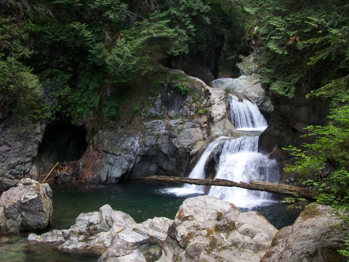
- LYNN CANYON PARK – North Vancouver
- SOUTH DYKE TRAIL – Richmond
- Running for 8km / 5 miles (16 km /10 miles round trip) along the south part of Richmond beginning in Steveston and running along Dyke Road
- Is a dog-friendly trail though dogs must be on leash
- Is rated as easy
- WEST DYKE TRAIL – Richmond
- Starting in the neighbourhood of Steveston it runs along for 6 km / 3.7 miles (12 km / 7.4 miles round trip) to the Middle Arm of the Fraser River
- Easily accessible by car, bicycle, and public transit
- Is rated as easy
So that’s a wee list of a few trails in the Greater Vancouver area. Hopefully this has piqued your interest and you will get outside in Vancouver too.
Some trails may be closed, have limited access, and / or other restrictions in place due to Covid-19.


Leave a note from your corner of the world — I’d love to hear it